The visible shape
A flooded tuff coneThe crescent is the exposed rim of a volcanic cone; part of the rim lies below sea level.
Explore Molokini’s wildlife, stories, geology and conservation—through records you can trace and a landscape you can see.
Explore the crater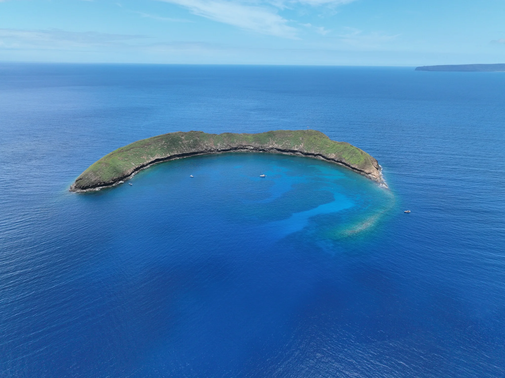 Friends of Molokini · Archive photograph
Start with the reef, the stories, or a question about caring for this place.
Explore documented fish, corals, invertebrates, seabirds and larger visitors.
ExploreFollow the cove, reef, outer wall and islet into deeper reading.
ExploreRead distinct recorded moʻolelo with sources and place connections.
ExploreTrace field surveys, wartime use, protection and research.
ExploreUnderstand noise, physical contact, wildlife responses and prevention.
ExploreSee the proposed evidence standards for responsible operation.
ExploreFind current rules alongside clearly labeled visitor guidance.
ExploreSee what the camera and environmental data can tell us together.
ExploreEach fact opens a larger story. Sources preserve the dates and qualifications.
The crescent is the exposed rim of a volcanic cone; part of the rim lies below sea level.
Molokini lies on East Maui volcano’s southwest rift zone.
Palmer describes tuff beds built from fragmented volcanic material and later altered and cemented.
USGS reported this estimate in 2001. A UH field guide gives approximately 150,000 years, citing a 2001 communication.
DAR gives the Molokini Shoal MLCD area as approximately 77 acres.
The exposed island has its own terrestrial protection and access restrictions.
Search by topic, then follow the sources and related pages.
A small islet appears in several different accounts of kinship, transformation, travel and skilled speech. Read each with its source and its differences intact.
In this version, Molokini is Puʻuoinaina’s head and Puʻuōlaʻi is her tail. The larger story also brings together birds, rain, kinship and Kahoʻolawe.
A rising hill, supporting turtles and a grandmother’s help form a very different recorded account of Molokini’s origin.
A separate Fornander narrative connects Molokini with Līhau, ʻEʻeke and Puʻulaina in west Maui—and preserves an easily lost detail about Pele’s younger sister.
Another account places Molokini within a birth relationship with Kahoʻolawe, preserving a different way of understanding the neighboring islands.
In the Fornander collection, Molokini appears in an island-name exchange during Kaipalaoa’s demanding contest of words.
Place names, a moʻo account and a fishpond tradition connect Molokini’s horizon with a lived coastal landscape.
The island across the channel has its own cultural relationships, restoration history and protected status. Its management plans offer a grounded introduction.
The crescent is the exposed part of a volcanic tuff cone on Haleakalā’s submerged flank. Its age is an estimate with published uncertainty.
A geologist’s map, ship soundings and a botanist’s specimen list reveal both the value and the limits of an early scientific portrait.
Official records document WWII-era munitions and a change from proposed remediation to a 2020 decision to leave two identified items in place.
The seabird island and the surrounding marine district are connected ecologically but have different boundaries, responsibilities and access rules.
Boat traffic and boat-supported recreation create pressures we can manage: physical reef contact, underwater noise, wildlife disturbance and preventable pollution. The evidence should guide specific action.
Molokini’s soundscape changes with vessel activity. A quieter visit is a practical stewardship goal, while reliable noise comparisons require underwater measurements.
A rare interruption in tourism offered researchers a natural experiment: what changes when a heavily visited marine reserve becomes quiet?
The compiled 2024 rules prohibit anchoring throughout the Molokini MLCD. Moorings, subzones and commercial permits each have their own requirements.
The most useful visitor briefing turns reef protection into actions people can follow before entering the water.
Trash does not belong on a reef. Protecting Molokini requires both strong prevention and careful evidence about where debris came from.
Heat stress, coral condition, pollution and vessel activity require different measurements. A beautiful camera image cannot stand in for all of them.
An observation, a visitor survey and a natural experiment answer different questions. Dates, methods and limitations make the archive useful.
The protection of Molokini has a documented history: early biological surveys, concerns about growing use, and direct observations of anchor damage.
What a local record proves, why historical names stay visible, and why an honest atlas has no single final species count.
Corals, worms, bryozoans, shrimp and other small animals give the reef much of its biological complexity.
The islet, its burrows and the surrounding airspace connect Molokini to the open ocean.
Compare methods and places before interpreting the changing lists of animals recorded at Molokini.
Place the crater within the seasonal life of the surrounding Maui Nui sanctuary.
Montipora capitata — Recorded in the Molokini column of the 31 May 2007 outer-rim survey. This confirms a historical local record, not current abundance or a guaranteed sighting.
Pocillopora meandrina — Recorded in the Molokini column of the 31 May 2007 outer-rim survey. This confirms a historical local record, not current abundance or a guaranteed sighting.
Porites lobata — Recorded in the Molokini column of the 31 May 2007 outer-rim survey. This confirms a historical local record, not current abundance or a guaranteed sighting.
Vittaticella uberrima — Recorded in the Molokini column of the 31 May 2007 outer-rim survey. This confirms a historical local record, not current abundance or a guaranteed sighting.
Caranx melampygus — Recorded in the Molokini column of the 31 May 2007 outer-rim survey. This confirms a historical local record, not current abundance or a guaranteed sighting.
Chaetodon miliaris — Recorded in the Molokini column of the 31 May 2007 outer-rim survey. This confirms a historical local record, not current abundance or a guaranteed sighting.
Labroides phthirophagus — Recorded in the Molokini column of the 31 May 2007 outer-rim survey. This confirms a historical local record, not current abundance or a guaranteed sighting.
Triaenodon obesus — Recorded in the Molokini column of the 31 May 2007 outer-rim survey. This confirms a historical local record, not current abundance or a guaranteed sighting.
Caranx ignobilis — Explicitly named for Molokini in NOAA’s 2005 fish rapid-ecological-assessment report.
Carcharhinus amblyrhynchos — The Molokini ISRA assessment identifies regular gray reef shark occurrence and seasonal observations of young sharks, based on diver records reported in 2024.
Rhincodon typus — DLNR reported a juvenile whale shark photographed on the backside of Molokini on 12 July 2018.
Eretmochelys imbricata — The HIhawksbills catalogue documents Molo1 at Molokini around 1999–2000 and Skinny Molo-Mini in 2003–2005 and 2007.
Neomonachus schauinslandi — NOAA’s critical-habitat rule identifies Molokini Crater as Maui Nui terrestrial habitat segment MAi1.
Ardenna pacifica — DLNR identifies wedge-tailed shearwaters as the principal resident birds of Molokini Islet Seabird Sanctuary.
Bulweria bulwerii — DOFAW lists Molokini among the main Hawaiian Island islets where Bulwer’s petrels breed.
Fregata minor — DLNR describes great frigatebirds often soaring over Molokini. This is not evidence of a breeding colony there.
No matching articles. Try a broader term or clear the filters.